Sunday, September 25, 2011

Travel Tips


To make your travel hassle free at BANGLADESH, please follow some rules. Some important tips to follow in Bangladesh:

1. While using public transports(bus, train, etc) do not accept or taste food or anything from any strangers.

2. Please do not go anywhere with a stranger who promises you a good spot or anything.

3. Try to go back to your hotel room when most people leave the travel spot.

4.It is good if you can come back your hotel before 10 o' clock and/or make sure your transport to go back to your hotel.

5. Don't take all your money, important papers and/or other important things with you when you went outside.

6. Alcohol and/or alcoholic beverage is illegal in Bangladesh. So it should be avoided.

7. Smoking cigarette in front of the seniors is treated as bad manners.

8. Please take off your shoes before going into any holy place, but don't keep your shoes in a place where there is a chance to be stolen. In many place there are paid arrangements for taking care of shoes. Use the facility or carry your shoes.

9. 
Kissing, hugging publicly are highly offensive . So these should be avoided.


10. The Chittagong Hill Tracts are experiencing high levels of politically motivated violence and kidnappings. Tourists should avoid all non-essential travel in this area.

Tuesday, September 20, 2011

Gazipur District


Map of Gazipur District.
Upazilas & Thanas:

Gazipur District (Dhaka division) with an area of 1741.53 sq km, is bounded by mymensingh and kishoreganj districts on the north, dhaka, narayanganj and narsingdi districts on the south, Narsingdi on the east, Dhaka and tangail districts on the west. Annual average temperature maximum 36°C and minimum 12.7°C; annual rainfall 2376 mm. Main rivers: old brahmaputra, shitalakshya, turag, bangshi, balu, banar.


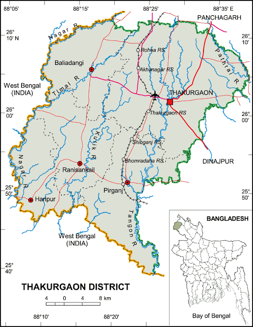
Thakurgaon District


Map of Thakurgaon District.
Upazilas & Thanas:

Thakurgaon District (Rangpur division) with an area of 1809.52 sq km, is bounded by panchagarh district on the north, west bengal of India on the west and south, Panchagarh and dinajpur districts on the east. Annual average temperature: maximum 33.5°C, minimum 10.5°C; annual rainfall 2536 mm. Main rivers are tangon, punarbhaba, nagar, Pathari, Talma, Kulic, dhepa.

Sylhet District


Map of Sylhet District.
Upazilas & Thanas:

Sylhet District (Sylhet division) with an area of 3490.40 sq km, is bounded by the Khasia-Jainta hills of India on the north, maulvi bazar district on the south, Kachhar and Karimganj districts of India on the east, sunamganj and habiganj districts on the west. Annual maximum temperature is 33.2°C and minimum is 13.6°C; annual rainfall 3334 mm. Main river is surma and kushiyara. haors 82; Shingua Beel (12.65 sq km) and Chatla Beel (11.86 sq km) are notable; reserve forest 236.42 sq km. Parts of Khasia and Jainta hills are included in this district. Notable tilas and hills are Jaintapur (54 m), Sary Tila (92 m), Lalkhan Tila (135 m), Dhaka Daksmin Tila series (77.7 m).

Tangail District


Map of Tangail District.
Upazilas & Thanas:

Tangail District (Dhaka division) with an area of 3424.39 sq km, is bounded by jamalpur district on the north, dhaka and manikganj districts on the south, mymensingh and gazipur districts on the east, sirajganj district on the west. Main rivers: jamuna, dhaleshwari, Jhenai, Bangshi, Lohajang, Turag. Madhupur forestry and Sukhipur and Ghatail hillocks are notable. Average annual temperature: maximum 33.3°C, minimum 12°C; annual rainfall 1467 mm.

Sunamganj District


Map of Sunamganj District.
Upazilas & Thanas:

Sunamganj District (Sylhet division) with an area of 3669.58 sq km, is bounded by Khasia and Jaintia hills (India) on the north, habiganj and kishoreganj districts on the south, sylhet district on the east, netrokona and greater mymensingh districts on the west. Annual average temperature: maximum 33.2°C and minimum 13.6°C; annual rainfall 3334 mm. There are many haors and beels in Sunamganj.

Sirajganj District


Map of Sirajganj District.
Upazilas & Thanas:

Sirajganj District (Rajshahi division) with an area of 2497.92 sq km, is bounded by bogra district on the north, pabna district on the south, tangail and jamalpur districts on the east, Pabna, natore and Bogra districts on the west. Main rivers are Jamuna, Baral, Ichamati, Karatoa and Phuljuri. About 10% area of the chalan beel is located in the tarash upazila of this district. Annual average temperature: maximum 34.6°C, minimum 11.9°C; annual rainfall 1610 mm.

Shariatpur District


Map of Shariatpur District.
Upazilas & Thanas:

Shariatpur District (Dhaka division) with an area of 1181.53 sq km, is bounded by munshiganj district on the north, barisal district on the south, chandpur district on the east, madaripur district on the west. Annual average temperature: highest 35.8°C and lowest 12.6°C; annual rainfall 2105 mm. Main rivers are Padma, Meghna, Palong and Kirtinasha.

Sherpur District


Map of Sherpur District.
Upazilas & Thanas:

Sherpur District (Dhaka division) with an area of 1363.76 sq km, is bounded by Garo hills of Meghalaya (India) on the north, mymensingh and jamalpur districts on the south, Mymensingh district on the east, Jamalpur district on the west. Annual average temperature maximum 33.3°C, minimum 12°C; annual rainfall 2174 mm; main rivers are Old Brahmaputra, Mrigi, Malijee, Bhogai, Chellashali and Maharashi. Shal, Segun and Gazari forests are notable.

Satkhira District


Map of Satkhira District.
Upazilas & Thanas:

Satkhira District (Khulna division) with an area of 3858.33 sq km, is a south west bordered district of Bangladesh. It is bounded by jessore district on the north, the bay of bengal on the south, khulna district on the east, Pargana district of west bengal on the west. Annual average temperature is maximum 35.5°C, minimum 12.5°C; annual rainfall 1710 mm. The soil of the district is alluvial floodplain. Main rivers are kobadak, Sonai, Kholpatua, Morischap, Raimangal, Hariabhanga, ichamati, Betrabati and kalindi-jamuna.

Rangpur District


Map of Rangpur District.
Upazilas & Thanas:

Rangpur District (Rangpur division) with an area of 2307.78 sq km, is bounded by nilphamari district on the north, gaibandha district on the south, kurigram district on the east and dinajpur district on the west. Main rivers are tista, Jamuneshwari, karatoya, Chikli and ghaghat. About 80% area of the district is composed of alluvial soil of Tista basin and 20% Barind land. Annual average temperature: maximum 32.3°C, minimum 11.2°C; total rainfall 2931 mm.

Rangamati District


Map of Rangamati District.
Upazilas & Thanas:

Rangamati District (Chittagong division) with an area of 6116.13 sq km, is bounded by the Tripura State of India on the north, bandarban district on the south, Mizoram State of India and Chin State of Myanmar on the east, khagrachhari and chittagong districts on the west. Annual average temperature: maximum 34.6°C, minimum 13.4°C; annual rainfall 3031 mm. Rivers are karnafuli, Thega, Horina, Kassalong, Shublang, Chingri, Rainkhiang and Kaptai.

Rajshahi District


Map of Rajshahi District.
Upazilas & Thanas:

Rajshahi District (Rajshahi division) with an area of 2407.01 sq km, is bounded by naogaon district on the north, West Bengal of India, kushtia district and the ganges on the south, natore district on the east and nawabganj district on the west. The region consists of barind tract, Diara and Char lands. Main rivers are padma (Ganges), mahananda, baral and Barnai. Annual average temperature: maximum 37.8°C, minimum 11.2°C; annual rainfall 1862 mm.

Pirojpur District


Map of Pirojpur District.
Upazilas & Thanas:

Pirojpur District (Barisal division) with an area of 1307.61 sq km, is bounded by gopalganj and barisal districts on the north, barguna district on the south, jhalokati district on the east, bagerhat district on the west. Annual average temperature: maximum 35.5°C, minimum 12.5°C; annual rainfall 1710 mm. Main rivers are Baleshwar, Katcha, Kaliganga and Sandhya.

Rajbari District


Map of Rajbari District.
Upazilas & Thanas:

Rajbari District (Dhaka division) with an area of 1118.8 sq km, is bounded by pabna district on the north, faridpur and magura districts on the south, manikganj district on the east, kushtia and Jhenaidah districts on the west. The land of the district is mainly alluvial raised from the Padma. Main rivers besides the Padma (Ganges) are Jalangi, kumar, gorai-madhumati, Harai and Chandana. Annual average temperature: maximum 35.8°C and minimum 12.6°C; annual rainfall 2105 mm.

Patuakhali District


Map of Patuakhali District.
Upazilas & Thanas:

Patuakhali District (Barisal division) with on area of 3204.58 sq km, is bounded by barisal district on the north, the Bay of Bengal on the south, bhola district on the east, barguna district on the west. The area of the district is composed of some small chars or islands. Maximum temperature 33.3°C and minimum 12.1°C; annual rainfall 2506 mm. Main rivers are the Andharmanik, Agunmukha, Payra, Lohalia, Patuakhali and Tentulia. The region having been close to the sea, frequently falls victim to tornado and tidal bore.

Panchagarh District


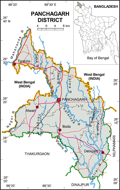
Map of Panchagarh District.
Upazilas & Thanas:

Panchagarh District (Rangpurdivision) extreme northern district of Bangladesh with an area of 1404.63 sq km is bounded on three sides by 288 km long Indian border, having Darjeeling district on the north, Jalpaiguri and Kuchbihar districts on the northeast, West Dinajpur and Purnea district on the west, dinajpur and thakurgaon districts on the south, nilphamari district on the east. Its soil is sandy, alluvial and bears close affinity with the soil of the old Himalayan basin. On the northern part of the district there exists underground layer of pebbles. Maximum temperature 30.2°C and minimum 10.1°C; annual total rainfall 2931 mm. Main rivers are Karatoya, Atrai, Tista, Mahananda, Tangon, Dahuk, Pathraj, Bhulli, Talma, Nagar, Chawai, Kurum, Versa, Tirnoi, Chilka.

Pabna District


Map of Pabna District.
Upazilas & Thanas:

Pabna District (Rajshahi division) with an area of 2371.50 sq km, is bounded by natore and sirajganj districts on the north, rajbari and kushtia districts on the south, manikganj and sirajganj districts on the east, ganges river and Kushtia district on the west. Average maximum temperature 33.9°C, minimum 9.6°C; annual rainfall 1872 mm. Characteristically the soil of the district is divided into four, viz flood plains of the Ganges, Karatoya, Jamuna and Barind Tract. Main rivers are Ganges, Ichamati, Gumani and Hurasagar.

Noakhali District


Map of Noakhali District.
Upazilas & Thanas:

Noakhali District (Chittagong division) with an area of 3600.99 sq km, is bounded by comilla district on the north, the Meghna estuary and the bay of bengal on the south, feni and chittagong districts on the east, lakshmipur and bhola districts on the west. Annual average temperature: maximum 34.3°C, minimum 14.4°C; annual rainfall 3302 mm. Main rivers are Bamni and meghna.

Nilphamari District


Map of Nilphamari District.
Upazilas & Thanas:

Nilphamari District (Rangpur division) with an area of 1640.91 sq km, is bounded by Kuchbihar district of west bengal (India) on the north, rangpur district on the south, lalmonirhat district on the east and panchagarh and dinajpur districts on the west. Annual temperature: maximum 32.3°C, minimum 11.2°C; annual rainfall 2931mm. Main rivers are Tista, Jamuneshwari, Chikni and Dhaigan.

Netrokona District


Map of Netrokona District.
Upazilas & Thanas:

Netrokona District (Dhaka division) with an area of 2810.40 km sq km, is bounded by Garo Hills of Meghalaya (India) on the north, kishoreganj district on the south, sunamganj district on the east and mymensingh district on the west. Annual temperature; Average maximum 33.3°C and minimum 12°C. Total rainfall 2174 mm. Main rivers are Someshwari, Kangsha, Magra, Dhanu, Dhala, Teorkhali.

Nawabganj District


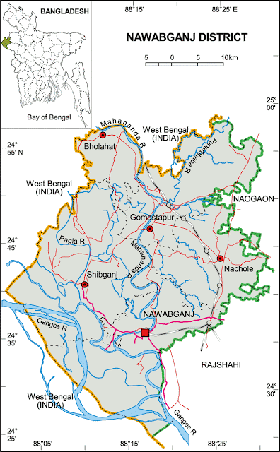
Map of Nawabganj District.
Upazilas & Thanas:

Nawabganj District (rajshahi division) with an area of 1744.33 sq km, is bounded by West Bengal of India on the north, south and west, rajshahi and naogaon districts on the east. The district lies under barind tract and consists of diaras and charlands (sandbars develop in riverbed). Main rives are ganges, mahananda, Pagla, Moraganga and punarbhaba. Beel Bhatia, Beel Choral, Beel Hogla, Beel Singra, Sukrabari Damos, Maricha Dara, Beel Putimari, Beel Anal, Kumiradaha are the noted depressions. Annual average temperature: maximum 37.8°C, minimum 11.2°C; annual rainfall 1862 mm.

Narayanganj District


Map of Narayanganj District.
Upazilas & Thanas:

Narayanganj District (Dhaka division) with an area of 759.57 sq km, is bounded by narsingdi and gazipur districts on the north, munshiganj districts on the south, brahmanbaria and comilla districts on the east, dhaka districts on the west. Average maximum temperature 36°C, minimum 12.7°C; annual total temperature 2376 mm. Physically the zila is characterised by alluvial formations caused by several rivers such as, shitalakshya, meghna, old brahmaputra, buriganga, balu and dhaleshwari.

Natore District


Map of Natore District.
Upazilas & Thanas:

Natore District (Rajshahi division) with an area of 1896.05 sq km, is bounded by naogaon and bogra districts on the north, pabna and kushtia districts on the south, Pabna and sirajganj districts on the east, rajshahi district on the west. Average annual temperature: maximum 37.8°C, minimum 11.2°C; annual rainfall 1862 mm. Rivers: 10 most noted of which are Atrai, Baral, Narod, Nandakunja; Chalan Beel is notable.

Narsingdi District


Map of Narsingdi District.
Upazilas & Thanas:

Narsingdi District (Dhaka division) with an area of 1140.76 sq km, is bounded by kishoreganj district on the north, narayanganj and brahmanbaria districts on the south, Brahmanbaria and Kishoreganj districts on the east, gazipur district on the west. Annual average temperature: maximum 36°C, minimum 12.7°C; annual rainfall 2376 mm. Main rivers are Meghna, Arial Khan, Haridhoa, Kalagachhia and Paharia. There are high hills with red soil on the northern region of the district.

Narail District


Map of Narail District.
Upazilas & Thanas:

Narail District (Khulna division) with an area of 990.23 sq km, is bounded by magura district on the north, khulna district on the south, faridpur and gopalganj districts on the east, jessore district on the west. Annual average temperature maximum 37.1°C, minimum 11.2°C; annual rainfall 1467 mm. Main rivers are madhumati, nabaganga, bhairab, chitra and Kajla. There are many beels and baors most noted of which is Chachuri Beel.

Naogaon District


Map of Naogaon District.
Upazilas & Thanas:

Naogaon District (Rajshahi division) with an area of 3435.67 sq km, is bounded by West Bengal of India on the north, natore and rajshahi districts on the south, joypurhat and bogra districts on the east, nawabganj district and West Bengal (India) on the west. Annual temperature: maximum 37.8°C and minimum 11.2°C; annual rainfall 1862 mm. Main rivers are atrai, punarbhaba, little jamuna, nagar, Chiri and Tulsi Ganga. Guta, Mansur and Dighali beels are notable.

Mymensingh District


Map of Mymensingh District.
Upazilas & Thanas:

Mymensingh District (Dhaka division) with an area of 4363.48 sq km, is bounded by Meghalaya State of India and Garo Hills on the north, gazipur district on the south, netrokona and kishoreganj districts on the east and sherpur, jamalpur and tangail districts on the west. The main river is Old Brahmaputra. Besides, there are small rivers, marsh, canals and forestry in the district. The soil formation of the district is flood plain, grey piedomont, hill brown and terrace. There are small valleys between the high forests; annual average temperature maximum 33.3°C, minimum 12°C; annual rainfall 2174 mm.

Meherpur District


Map of Meherpur District.
Upazilas & Thanas:

Meherpur District (Khulna division) with an area 716.08 sq km, is bounded by kushtia district and West Bengal of India on the north, chuadanga district and West Bengal on the south, Chuadanga and kushtia districts on the east, West Bengal on the west. Main rivers are Bhairab, Mathabhaga and Kazli; Main depressions: Dharlar Beel, Chandbeel, Kolar Beel, Patapukur Beel, Gopalpur Beel, Bamandi Beel, Salika Beel, Terogharia Beel, Elangi Beel. Annual average temperature: highest 37.1°C and lowest 11.2°C; annual rainfall 1467 mm.

Munshiganj District


Map of Munshiganj District.
Upazilas & Thanas:

Munshiganj District (Dhaka division) with an area of 954.96 sq km, is bounded by dhaka and narayanganj districts on the north, madaripur and shariatpur districts on the south, comilla and chandpur districts on the east, Dhaka and faridpur districts on the west. Main rivers are the padma, meghna, dhaleshwari, ichamati and shitalakshya. The southern and eastern parts of the district often fall victim to erosion caused by the mighty Padma and the Meghna respectively. Main depression is Arial Beel covering an area of 4330 hectare. Annual temperature- maximum 36°C and minimum 12.7°C; total rainfall 2376 mm.

Maulvi Bazar District


Map of Maulvi Bazar District.
Upazilas & Thanas:

Maulvi Bazar District (Sylhet division) with an area of 2799.39 sq km, is bounded by sylhet district on the north, Tripura state of India on the south, Assam and Tripura states of India on the east, and habiganj district on the west. Main rivers are manu, Dhalai, Juri, Gopala, etc; noted depressions: Hakaluki, Hail and Kawadighi Haors. Annual temperature: maximum 33.2°C, minimum 13.6°C; annual rainfall 3334 mm. The total forest area is 413.65 sq km (about 15% of the total area of the district); noted forest ranges are Patharia, Sanrer Gaz or Longla, Rajkandi and Vanugachh.

Manikganj District


Map of Manikganj District.
Upazilas & Thanas:

Manikganj District (Dhaka division) with an area of 1378.99 sq km, is bounded by tangail district on the north, dhaka district on the east, faridpur and Dhaka districts on the south, the padma, jamuna and the districts of pabna and rajbari on the west. Annual temperature: maximum 36°C and minimum 12.7°C; annual rainfall 2376 mm. Main rivers are the Padma, Jamuna, Dhaleshwari, Ichamati and Kaliganga. An extensive area of the district especially riverine area of the upazilas of Harirampur, Shivalaya and Daulatpur becomes victim to riverbank erosion every year.

Magura District


Map of Magura District.
Upazilas & Thanas:

Magura District (Khulna division) with an area of 1048 sq km, is bounded by Rajbari district on the north, Jessore and Narail districts on the south, Faridpur district on the east and Jhenaidah district on the west. Annual average temperature: maximum 37.1°C, minimum 11.2°C; annual rainfall 1467 mm. Main rivers are Gorai, Madhumati, Nabaganga and Fatki; Ramsagar and Bural Baor are notable.

Madaripur District


Map of Madaripur District.
Upazilas & Thanas:

Madaripur District (Dhaka division) with an area of 1144 sq km, is bounded by Faridpur and munshiganj districts on the north, barisal district on the south, shariatpur district on the east, gopalganj district on the west. Main rivers are padma, arial khan and kumar. Temperature: average maximum 35.8°C, minimum 12.6°C. Total rainfall 2105 mm.

Lalmonirhat District


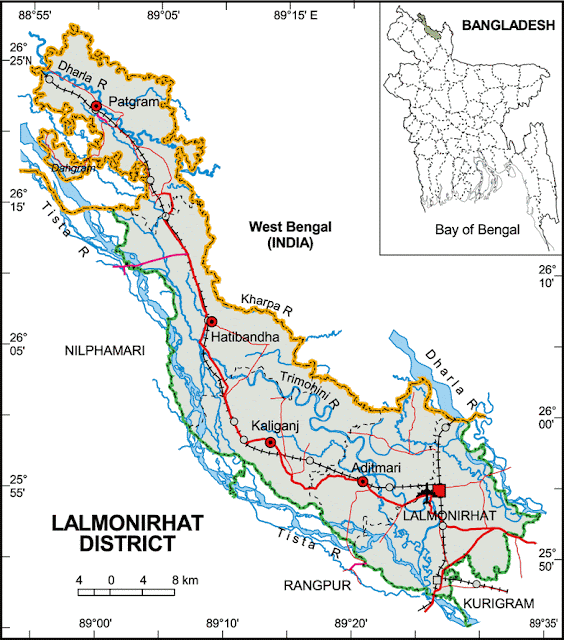
Map of Lalmonirhat District.
Upazilas & Thanas:

Lalmonirhat District (Rangpur division) with an area of 1241.46 sq km, is bounded by Kuchbihar and Jalpaiguri districts of West Bengal (India) on the north, rangpur district on the south, kurigram district and Kuchbihar district of West Bengal on the east, Nilphamari and Rangpur districts on the west. The district is striped shape. Main rivers 7, most noted of which are Tista, Dharla and Saniajan. The river Saniajan originating from the Himalaya has strong current. Sarnamati, Trimohoni, Ratnai and Sati rivers are almost silted. The biggest irrigation project of the country, Tista Barrage Project (length 615 m) is located at Doani of Hatibandha upazila. Temperature: highest 32.3°C, lowest 11.2°C; total rainfall 2931 mm.

Lakshmipur District


Map of Lakshmipur District.
Upazilas & Thanas:

Lakshmipur District (Chittagong division) with an area of 1455.96 sq km, is bounded by chandpur district on the north, bhola and noakhali districts upazilas on the south, Noakhali district on the east, barisal and Bhola districts and the meghna and on the west. Maximum temperature 34.3°C, minimum 14.4°C; annual rainfall 3302 mm. Main rivers are the Meghna, dakatia, Katakhali, Rahmatkhali and Bhulua.

Kushtia District


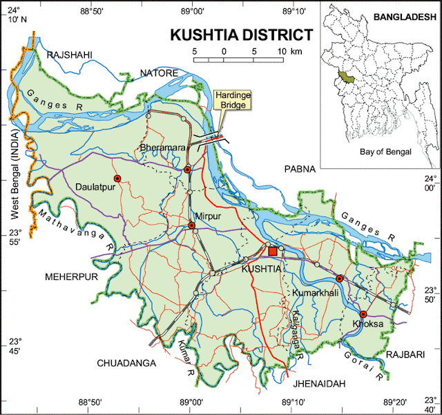
Map of Kushtia District.
Upazilas & Thanas:

Kushtia District (Khulna division) with an area of 1621.15 sq km is bounded by rajshahi, natore, pabna districts on the north, chuadanga, Jhenaidah districts on the south, rajbari districts on the east, West Bengal of India and meherpur district on the west. Main rivers are Ganges, Garai, Mathabhanga, Kaliganga and Kumar. Annual average highest temperature 37.8ºC and lowest 11.2ºC; annual rainfall 1467 mm.

Kurigram District


Map of Kurigram District.
Upazilas & Thanas:

Kurigram District (Rangpur division) with an area of 276.45 sq km, is bounded by Cooch Bihar district of west bengal on the north, gaibandha district on the south, Asam Province of India on the east, West Bengal of India and rangpur and lalmonirhat districts on the west. Annual average temperature: maximum 32.3°C, minimum 11.2°C; annual rainfall 2931 mm. Main rivers: brahmaputra, dharla, tista, dudhkumar, Phulkumar, Sonaburi, Jinjiram Gangadhar, Halhali and Jalchira.

Kishoreganj District


Map of Kishoreganj District.
Upazilas & Thanas:

Kishoreganj District (Dhaka division) with an area of 2688.62 sq km, is bounded by netrokona and mymensingh districts on the north, narsingdi district on the southwest and brahmanbaria district on the southeast, sunamganj and habiganj districts on the east, gazipur and Mymensingh districts on the west. The soil formation of the district is alluvial sand coming from Brahmaputra, Meghna and other small rivers. The soil is fertile. Annual average temperature- maximum 33.3°C, minimum 12°C; annual rainfall 2174 mm. There are hills and hillocks on the northern and depressions on southern parts of the district. Main rivers are old brahmaputra, meghna, Kalni, Dhanu, Ghorautra, Baurii, Narasunda, Piyain; main depressions: Humaipur (Bajitpur), Somai (Nikli), Barir (Mithamain), Surma Baula (Nikli), and Tallar Haors (Nikli-Bajitpur-Austagram).

Khulna District


Map of Khulna District.
Upazilas & Thanas:

Khulna District (Khulna division) with an area of 4394.46 sq km, is bounded by jessore and narail districts on the north, the bay of bengal on the south, bagerhat district on the east, satkhira district on the west. Annual average temperature is 35.5°C and lowest 12.5°C; annual rainfall is 1710 mm. The main rivers are Rupsa-Pasur, Bhairab, Shibsha, Dharla, Bhadra, Ball, and Kobadak. Forest: sundarbans (166814 hectares).

Khagrachhari District


Map of Khagrachhari District.
Upazilas & Thanas:

Khagrachhari District (Chittagong division) with an area of 2699.55 sq km, is bounded by the Indian State of Tripura on the north, rangamati and chittagong districts on the south, Rangamati district on the east, Chittagong district and the Indian State of Tripura on the west. Annual average temperature: maximum 34.6ºC, minimum 13ºC; annual rainfall 3031 mm. The hills of this region are composed of folded sedimentary rocks. Notable hill ranges Alu Tila, Bhanga Mura (416.66 m), Matai Pukhiri (213.36m), Matai Lakho (274.32 m); main rivers are Chingri, Maini, Feni and Halda; lake Mataipukhiri (Debotar pukur).

Joypurhat District


Map of Joypurhat District.
Upazilas & Thanas:

Joypurhat District (Rajshahi division) with an area of 965.44 sq km, is bounded by dinajpur district on the north, naogaon districts on the south, bogra and gaibandha districts on the east, Bogra and Naogaon districts and Indian province of west bengal on the west. Main rivers are little jamuna, Tulsi Ganga and Haramati. Annual average temperature: maximum 34.6°C, minimum 11.9°C; annual rainfall is 1610 mm.